[The first occurrence of «Os Palheiros» in a chart that I have found so far is in {map#824 Livro de Marinharia, de João de Lisboa, João de Lisboa, 1560, PT/TT/CRT/166, Arquivo Nacional, Lisbon}. It has two main variants «ospalheiro» and «spalheiro» which appear in some maps until about 1740 after which it appears to be corrupted to «spallura». Its position also changes from south of Ras al Had about al Ashkharah further south to Ras ar Ruwais.] PBR
In 1835 Os Palheiros was shown as a range of hills «Os Palheiros» in {map#850 6. Arabia und das Nil-Land, Berghaus, Heinrich, 1835, David Rumsey Map Collection list no: 15177.003} is shown as a line of hills from lat 21.221056°long 58.357285° to lat 21.508164° long 58.951825° in a heading of about 66º and west of «Ras Djibsch».
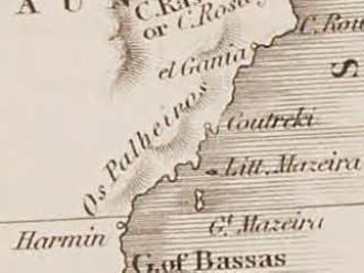
«Owen fuhr zwischen Ras Djibsch und Ras Markas längs der Ostseite der grofsen In- sel Massera; die Küste des vesten Landes konnte er nicht aufnehmen, weil er sich derselben in dem Kanale von Massera wegen der vielen Untiefen, die daselbst ausgebreitet liegen, nicht zu nähern ver- mogte. In den alten portugiesischen Berichten kommt eine Ensanada das Baxas (Einfahrt der Untiefen) so wie eine kleine Insel Massera oder Maceira vor; beide hat Kapit. Owen, des erwähn- ten Umstandes wegen, nicht gesehen, eben so wenig die Stadt Harmin und die Bergkette Os Palheiros.» [Owen sailed between Ras Djibsch and Ras Markas along the east side of the great island of Massera; he could not take the coast of the west country, because he could not approach it in the Channel of Massera, on account of the many shoals that lie spread out there. In the old Portuguese accounts there is an Ensanada das Baxas (Entrance of the Shallows) as well as a small island of Massera or Maceira; both has Kapit. Owen, for the aforesaid circumstance, not seen, nor the town of Harmin and the Os Palheiros mountain range. #2654 Heinrich Karl Wilhelm Berghaus, Geo-Hydrographisches Memoir zur Erklärung Und Erlauterung der General-Karte von Arabia und dem Nil Land E. (No. 6. Von Berghaus' Atlas Von Asia.), Justus Perthes, 1835 ~ p.77
«In allen portugiesischen Berichten, sagt Berghaus), fomme in dieser Gegend die Einfahrt der Untiefen, Ensanada das Baxas vor, und eine kleine ber Küste nabgelegene Jufel, Klein-Maceira, die von Capt. Owen so wenig wie die dortige Stadt Harmin und die Küstenkette os Palheiros gesehen ward; daher hier die Zeichnung der Berghaustschen Karte auch nur hypothetisch geblieben ist.» [In all Portuguese reports, says Berghaus, the entrance to the shallows, Ensanada das Baxas, occurs in this region, and a small jufel, Klein-Maceira, remote from the coast, which Capt. Owen as little as that the city of Harmin and the coast chain os Palheiros was seen there; therefore the drawing of Berghaus's map remained only hypothetical here.] in #2653 Carl Ritter, Die Erdkunde von Asien von Carl Ritter. Band VIII. Erste Abtheilung. Die Halbinsel Arabien., G. Reimer, Berlin, 1846 ~ pp. 347-8
#2631 Owen, W. F. W, Narrative of voyages to explore the shores of Africa, Arabia, and Madagascar; performed in H.M. ships Leven and Barracouta, under the direction of Captain W.F.W. Owen, Richard Bentley, New Burlington Street, London, 1833 ~ vol. 1 pp. 210-211.
Names of Places are given by Owen in the tables at the end of #2632 William Fitzwilliam Owen, Richard Owen, Tables of latitudes and longitudes by chronometer of places in the Atlantic and Indian Oceans principally on the west and east coast of Africa, the coasts of Arabia, Madagascar etc. resulting from the observations of H. M. S. Leven and Barraconta in the years 1820 to 1826, Duckworth, 1827 ~
A chart at the British Library, {map#855 Africa, Sheet VI from the Juba Islands to Maskat with the Entrance to the Red Sea' [1r] (1/2), Captain William Fitzwilliam Owen, 1877, British Library IOR/X/3828/598} was compiled under the direction of Captain William Fitzwilliam Owen from 1822 to 1826. North of 10° N the chart is compiled from reductions of more recent surveys by 'the East India Company's Officers'. Engraved by J and C Walker. Published by the Admiralty 1827, with corrections 1868, 1873, 1875, November 1876, December 1876, May 1877 and September 1877. There is no indication of Os Palheiros in either the books above or on the chart.
« [margin: 15 On the 15th, with the wind blowing from the same direction as yesterday, just after dawn we sighted the palheiros,(34) which is what the Portuguese sailors call certain hills that can be seen on the mountaintops; they look like the sheaves of wheat [fol. 165v or barley in Spain that are normally raked into piles to separate the chaff from the wheat. There are three or four of these small hillocks in plain sight of those who sail past them. These palheiros come into the view of those who sail with a favorable monsoon on this voyage before any other section of land along the Arabian Coast. fn. 34 Portuguese for “haystacks.” »
Excerpt from #2651 trans. and ed; Jeffrey S. Turley and George Bryan Souza, The Commentaries of D. García de Silva y Figueroa on his Embassy to Shah ʿAbbās I of Persia on Behalf of Philip III, King of Spain, Brill, Leiden, 2017 ~ p. 253-255
« PALHEIROS, Os - Nome de que Couto usa para designar um local da costa árabe compreendida entre os ras ou cabos Jibsh (21° 27' lat. N. e 59° 20' long. E.) e Gumeila (21° 58' lat. N. e 59° 40' long. E.), se é que o não aplica a toda a dita costa. O nome português - os Palheiros - subsiste próximo do cabo Gumeila, no local que as cartas do Almirantado britânico denominam Haycock, em 21° 56' lat. N. e 59° 27' long. E. [Diogo do Couto - Da Asia]. [PALHEIROS, Os - Name used by Couto to designate a place on the Arabian coast between the ras or capes Jibsh (21° 27' lat. N. and 59° 20' long. E.) and Gumeila (21° 58' lat. .N. and 59° 40' long. E.), if it does not apply to the entire said coast. The Portuguese name - the Palheiros - subsists near Cape Gumeila, in the place that the charts of the British Admiralty call Haycock, at 21° 56' lat. N. and 59° 27' long. E. [Diogo do Couto - From Asia].] » #2603 Visconde De Lagoa, Glossario Toponimico Da Antiga Historiografia Portuguesa Ultramarina, Oficina Grafica, Casa Portuguesa Rua Das Gaveas, 1953 ~ p.19
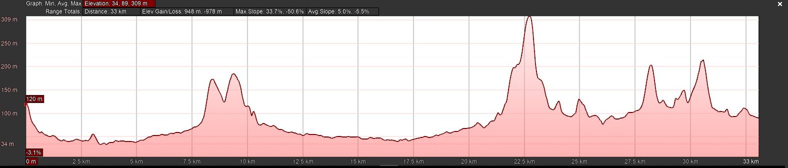
[Using USGS contours with an overlay of the Berghaus range of hills {map#850 6. Arabia und das Nil-Land, Berghaus, Heinrich, 1835, David Rumsey Map Collection list no: 15177.003} showed 3 peaks at 221m (lat 21.440095° long 58.397177°) 262m (lat 21.461853° long 58.600799°) and 172m (lat 21.500024° long 59.002707°) in a line from west to east. The west end of the above “Berghaus range of hills” is 24kms south of peak 221m and the east end 5km short of peak 172m.] PBR
«Haycock» is shown in {map#870 Chart of the North-East Coast of Arabia, Commander I P Sanders and Lieutenant Albany Moore Grieve, Indian Navy, 1854, British Library, India Office, IOR/X/3635/20} and again more detailed in {map#883 'Arabian Sea', Stafford Bettesworth Haines and I P Sanders, 1899, British Library, Ref: IOR/X/3828/1012}.
Haycock (lat. 21.897589 long 59.468913°) is some 90 kms north east of the Berghaus range of hills, nearer to the coast and with a profile more indicative of García de Silva y Figueroa’s description. PBR

elevation profile along line of Berghaus range of hills
elevation profile in map#870 Chart of the North-East Coast of Arabia
Haycock is centre right
« os palheiros } Ghubbat al-Hashish? » Excerpt from #32 Tibbetts, G. R., Arabia in the Fifteenth-Century Navigational Texts, Arabian Studies, London and Basingstoke, 1974 1:98 ~ p. 99
«a town at the eastern extremity of the Gulf of Bassa, between Harmin and Ras-al-Hhad. Inland, north of Abissa and its Gulf, the Didymi Montes of Ptolemy obviously correspond with the Palheiros mountains lying north of the Gulf of Bassas. This region is the Libanotophoros, or region of frankincense. Ptolemy's Bosara» #365 Forster, The Rev. Charles, The Historical Geography of Arabia, Darf Punlishers Limited, London, 1846 ~ vol.2 p. 181-3 and pp. 235-6
«HARMIN, a village of Arabia, on the SE coast of Oman, opposite the island of Maceira.» #2685 ed. Member of the RGS, A Gazetteer of the World, or Dictionary of Geographical Knowledge Vol. III Derrygate-Hensall, A. Fullarton, Edinburgh, 1856 ~ p. 816
Hormanus fl., a r. of Arabia Felix, falling into Erythraeum mare s.w. of Abissa, Harmin. [no separate listing for Abissa or Harmin] #682 Hazlitt, William, The Classical Gazetteer, A Dictionary of Ancient Sites, Senate, London, 1851 ~ p.178
«If we inquire to what extent the process of direct identification may be carried, in its application to the cities and towns of the peninsula, without borrowing a single example from the more familiar nominal coincidences accumulated by d'Anville, the names of Hormanus —Harmin bear ample evidence, by the agreements which they establish between its ancient and its modern towns and cities, ... an identity, not in names only, but also in geographical positions, . . . that Arabia, at the present day, still retains numerous obvious characters and land-marks, of its classical nomenclature and localities. » #365 Forster, The Rev. Charles, The Historical Geography of Arabia, Darf Publishers Limited, London, 1846 ~ p. lxix, lxx
«Harmin, a town on the coast of Arabia, proviuce of Hadramaut» #2635 London Universal Gazetteer, The New London Universal Gazetteer, Or Alphabetical Geography ... Illustrated by Maps and Engravings ... Third Edition, George Virtue, 1826 ~ p. 410
«Division. — 6. Oman, or Mufcat, is the largest and moft confiderable Kingdom of Arabia.
Chief Towns. — Distance and Bearing.
Niban — 60 NE of Mirabat
Mufcat — 400 NE of Niban
Hafen —70 NE of Niban
Harmin — 160 NE of Hafen
Ganca — 120 S of Mufcat
Sohar — 10 NW of Mufcat
Julphar — 130 E of Sohar
Elcatiff — 350 E of Elcatiff »
In #2688 Joseph Randall, A System of Geography or, A Dissertation on the Creation and Various Phaenomena of the Terraqueous Globe …, J. Lord, London, 1744 ~ p. 416
In his book Mitchell lists Harmin twice, both in Arabia but one a town the other a cape. #2689 Samuel Augustus Mitchell, An Accompaniment to Mitchell's Map of the World, on Mercator's Projection, S. Augustus Mitchell, Philadephia, 1846 ~ p.47
Harmin shown west of southern end of Masirah Island in
 {map#907 Asia upon the Globular Projection, Eman. Bowen, 1762, #2687 Benjamin Martin, Physico-geology: or, A new system of philosophical geography. Containing a new and general description of the terraqueous globe, etc, W. Owen, London, 1769 ~} |
 {map#901 Cart de la Turquie de l'Arabie et de la Perse, G. de l'Isle et Ph. Buache, 1780, } |
 {map#900 L'Arabia Divisa in Petrea, Deserta, e Felice, G. Titteri ser, 1784, Atlante novissimo vol. 4} |
 {map#906 Map of Arabia engraved for
the Modern Traveller, Josiah Conder, 1825, #2686 Josiah Conder, The
Modern Traveller. A description, geographical, historical, and
topographical, of the various countries of the globe. Vol. IV
Arabia, J. Duncan, London, 1830 ~} |
| In allen portugiesischen
Berichten, sagt Berghaus), fomme in dieser Gegend die Einfahrt der
Untiefen, Ensanada das Baxas vor, und eine kleine ber Küste nabgelegene
Jufel, Klein-Maceira, die von Capt. Owen so wenig wie die bortige Stadt
Harmin und die Küstenkette os Palheiros gesehen ward; daher hier die
Zeichnung der Berghaustschen Karte auch nur hypothetisch geblieben ist.
Die von S,W. gegen N.D. auf 30 Sees meilen langgestreckte, schmale
Insel Groß-Massera oder Maceira, niedrig, rauh von Ansehn, ift dagegen
zwischen 20° 7 und 20° 40′ mit den Süd- und Nordſpigen eingezeichnet,
che noch 40 Seemeilen weiter in N.D. bas sehr hohe Vorgebirge Omans Ras
Djibsch, unter 21° 25' 48" N.Br. und 56° 45" D.L. v. Gr., folgt, das
von Capt. Owen viel höher, wilder, abschreckender von Aus- sehen
vorgefunden ward, als das noch öftlichere viel berühmtere Ras el had,
zu welchem aber die hohe Küstenkette sich schon ge- gen N.N.D. so
bedeutend hin abgestuft hat, daß dieſes Ras el Had (unter 22° 33′ 12″
N.Br. und 57° 32′ D.) nur in eine niedere sandige Landspige ausläuft,
von der aber nun die Nordwestrichtung der Küfte beginnt, und von wo an
das Meer den Namen Bahr Oman erhält. |
In all the Portuguese
reports, says Berghaus, the entrance to the shallows, Ensanada das
Baxas, occurs in this region, and a small jufel off the coast, Little
Maceira, which Capt. Owen was seen as little as the local town of
Harmin and the coast chain os Palheiros; therefore the drawing of
Berghaust's map remained only hypothetical here. The S,W. against N.D.
at 30 nautical miles long, narrow island of Great Massera or Maceira,
low, rough in appearance, if on the other hand between 20° 7 and 20°
40′ with the south and north directions drawn, is still 40 nautical
miles further in N.D. bas very high promontories of Oman Ras Djibsch,
at 21° 25' 48" N.Br. and 56° 45" D.L. v. Gr., follows that of Capt.
Owen was found to be much higher, wilder, more forbidding in appearance
than Rasel, which was still more common and much more famous, to which,
however, the high coastal chain already approached towards N.N.D. so
significantly that this Ras el Had (below 22° 33′ 12″ N.B. and 57° 32′
D.) only ends in a low sandy headland, from which the north-west
direction of the coast now begins, and from where the sea gets the name
of Bahr Oman. |
| Pour couper court au mal,
le roubban quitta donc la partie, et vint se réfugier à l'abri de la
petite fle de Hemr, située à 19° 40′ de latitude nord, 55° 50' de
longitude est. … Dans un instant les grappins sont à la mer, et
nous mouillons dans le port de Harmin, à 20º de latitude nord, 55° 34'
de longitude est. Harmin est le chef-lieu d'un petit pays gouverné par
un sultan actuellement soumis à l'imam de Mascate. C'est une ville
remarquable par son étendue et ses nombreuses mosquées, mais située à
une demi-lieue de la mer et environnée de sables arides et stériles;
derrière elle seulement, et à une certaine distance, se distinguent une
forêt de dattiers, de belles plantations variées, des troupeaux et
quelques hameaux dont les habitants autrefois se livraient surtout à la
piraterie. Sa population est de six à sept mille âmes; celle-ci est
sédentaire, industrieuse et laborieuse. On trouve dans ce port un café
construit en branches et recouvert d'algues marines; un bazar où les
Bédouins environnants vendent de l'eau douce, du sel d'une blancheur
éblouissante, des dattes, du lait, des moutons, des chèvres et du
poisson. Tous ces Bédouins, au nombre de vingt-cinq à trente mille, et
qui, comme tous ceux de cette côte depuis Dhafar, approvisionnent les
boutres, sont secs, maigres et nerveux. ... Mardi, mercredi, jeudi,
vendredi et samedi 17, 18, 19, 20 et 21 octobre 1844 (16, 17, 18, 19 et
20 chaouál 1261). Le 17, de bonne heure, je suis réveillé par les cris
des matelots, occupés à hisser la voile gonflée par la brise de terre.
A peine hors du port, nous sommes de nouveau surpris par un calme plat,
et la Khethaêfa se balance mollement sous la lame jusqu'à trois heures.
A ce moment, la brise recommence à souffler, et, au coucher du soleil,
le roubban vient mouiller par 20° 15' de latitude nord, 55 46' de
longitude est, à l'abri de Masséra-Petite. Je dis petite par opposition
à Masséra-Grande, sise à quelques lieues en face. Cette ile, dis-je au
nacoda me parait aussi sté rile que celle de Hemr; cependant, il me
semble distinguer des habitants sur la rive. |
To cut short the evil, the roubban therefore left the game, and came to take refuge in the shelter of the small island of Hemr, located at 19° 40′ north latitude, 55° 50' east longitude. … In a moment the grapnels are at sea, and we anchor in the port of Harmin, at 20° north latitude, 55° 34' east longitude. Harmin is the capital of a small country ruled by a sultan currently subject to the imam of Muscat. It is a city remarkable for its extent and its numerous mosques, but situated half a league from the sea and surrounded by arid and sterile sands; only behind it, and at a certain distance, can be distinguished a forest of date palms, beautiful varied plantations, herds and a few hamlets whose inhabitants formerly devoted themselves chiefly to piracy. Its population is from six to seven thousand souls; this one is sedentary, industrious and laborious. In this port there is a café built of branches and covered with seaweed; a bazaar where the surrounding Bedouins sell fresh water, dazzlingly white salt, dates, milk, sheep, goats and fish. All these Bedouins, to the number of twenty-five to thirty thousand, and who, like all those on this coast from Dhafar, supply the dhows, are lean, thin and nervous. … Tuesday, Wednesday, Thursday, Friday and Saturday October 17, 18, 19, 20 and 21, 1844 (16, 17, 18, 19 and 20, Chaouál 1261). On the 17th, early in the morning, I was awakened by the cries of the sailors, busy hoisting the sail swollen by the land breeze. Barely out of the port, we are again surprised by a flat calm, and the Khethaêfa sways gently under the waves until three o'clock. At this moment, the breeze started to blow again, and, at sunset, the roubban anchored at 20° 15' north latitude, 55 46' east longitude, sheltered by Masséra-Petite. I say small as opposed to Masséra-Grande, located a few leagues opposite. This island, I say to the nacoda, seems to me as sterile as that of Hemr; however, I seem to distinguish inhabitants on the bank. |
Du Couret sailed in a Persian vessel, presumably of shallow draught as it kept inshore, from Mokallâh to Muscat in 1844 and provided a detailed account of the southern Arabian coast, which Capt. Owen had not been able to do in his survey of 1823 as his chart, published in 1830, states around the coastline of Mazeira Gulf, “Imperfectly Known”. {map#854 Chart Intended as an Accompaniment to the Book of Directions for Navigating to, from, and in the East Indies. Engraved by John Bateman, Admiralty, 1830, British Library IOR/X/3630/14} Du Couret’s voyage is easily followed from Dhofar northwards to Hemr, Jazirat Hamar an Nafur, though his observations in distances and co-ordinates are well askew at this stage but his observation «we anchor in the port of Harmin ... a city remarkable for its extent and its numerous mosques, but situated half a league from the sea and surrounded by arid and sterile sands; only behind it, and at a certain distance, can be distinguished a forest of date palms, beautiful varied plantations, herds and a few hamlet».
It is difficult to match Du Couret's description of Harmin within the current landscape. Hayy might fit the green area but is 20 kms from the shore. Filim might be Harmin but is small and on the shoreline. Khaluf to the west:
«Khaluf is an unprepossessing collection of mud huts on a bare repellent plain with a sea-front of perhaps half a mile, off which a few fishing badans may be at anchor. The plain runs back a mile in depth, surrounded by low flat shale hills. Fishermen sit every where making nets …» #2698 Bertram Thomas, The South-Eastern Borderlands of Rub' al Khali, The Geographical Journal, London, 1929 Vol. 73:No. 3: pp. 193-212 ~ p. 199
«The South-East Coast and Dhofar ... The strip of country from the S. border of Ja'lan to Ras Nus, which marks the eastern limit of Dhofar, has no general title but falls within the area of the Oman Sultanate. It is a barren stretch of coast, nearly 450 miles in length, backed by the Great Desert, and it possesses no place of importance with the exception of Mahot.» #2699 Admiralty War Staff, Intelligence Department, Handbook of Arabia Vol. 1 General, H.M.S.O., London, 1917 ~ pp. 276-7
«International trade from the South Arabian period onwards was defined archaeologically by the presence of amphorae that began to flood the market by the third century ВС. … Complete examples of these vessels have remarkably survived in Salalah houses, the tomb of Saleh bin Hud, and the largest number from Mahawt and Filim near Masirah.» #2665 Lynne S. Newton and Juris Zarins, Preliminary results of the Dhofar archaeological survey, Proceedings of the Seminar for Arabian Studies, London, 2009 vol. 40:pp. 247-265 ~ p. 257
If we accept Forster's suggestion that Harmin is derived from Hormanus and that it was a town then it might be similar in circumstance to Hormuz, originally on the mainland, Filim, thenmoved to the island of Mahot.
Occurences of Laços and Caços in accounts of tribute paid to Hormuz.
Miles ― De Barros gives a curious and detailed account of the revenue and expenditure of Hormuz at this time. He says that on the coast of Arabia the chief town was Kilhat, the governor and customs master at which overruled those in the other towns in the principality. The revenue collected and remitted by Kilhat to Hormuz was 19,200 sharafins, equal to 5.760 dollars, which was contributed in the following proportion: Kilhat, paid 1,100 ashrafies, Muscat 4,000, Sohar 1,500, Khor Fakan 1,500, Dibba 500, and Lima 700. The Julfar district or pirate coast also paid 7.500, and in addition to the above, the boats engaged in the pearl fishery, which were compelled to go to Hormuz to take out passes, contributed 1,500 ashrafies. The Oman revenue thus came to 28,200 ashrafies. The total revenue of Hormuz is said to have been 198,078 ashrafies. or 59,423 dollars.
Excerpt from #355 Miles, Samuel Barrett, The countries and tribes of the Persian Gulf, Harrison and Sons: Garnet Publishing Limited, London:Reading, 1919:1994 ~ p. 155
Aubin ― Le principal de ceux-ci sur la côte d'Arabie est le bourg (vila) de Qalhāt (Calayate), qui rend dix-neuf mille deux cents asra[i, de la maniere suivante : Calayate meme onze mille, Mascate quatre mille, Sohar (Soar) mille cinq cents, Khurfakkan (Orfacam) autant, Daba cinq cents, « Laços » sept cents. Gulffar (Julfar), qui est un autre vizirat dans cette region de I'Arabie, produit avec sa circonscription sept mille cinq cents asrafi. N'entrent pas dans ce chiffre certaines barques de pêche des peries qui se pêchent là, car elles sont astreintes à aller payer à Ormuz, vu qu'elle est proche; ce qu'elles y paient vaut mille cinq cents asrafi.
Excerpt from #2595 Jean Aubin, 1bis Revenus du Royaume d'Ormuz et dépense du Roi en 1515[?] (Barros, Asia, II / 10-7), Mare Luso-Indicum, Geneva, 1973 II:IV/5:pp. 233-237 ~ p. 233
ASIA ed. 1552 ― Image excerpt from #2598 João de Barros, Ásia de Joam de Barros, dos fectos que os Portugueses fizeram no descobrimento et conquista dos mares et terras do Oriente. Impressa per Germão Galharde em Lixboa : a. xxviii. de Junho anno de. mdlii., Germão Galharde, Lisbon, 1552 ~ Decada II. Liv. X fol. 141 reverso

ASIA ed. 1777 ― Image excerpt from #1858 Da Asia de João de Barros Dos Feitos, Que Os Portuguezes Fizeram No Descubrimento, E Conquista Dos Mares, e Terras do Oriente., Na Regia officina typografica, Lisboa, 1777 ~ T. 2 Pt. 2 p. 478 (Decada II. Liv.X.Cap. VII. 478)


ASIA ed. 1945 ―Image Excerpt from #810 Barros, Joâo de ed: Cidade, Hernâni, Ásia de João de Barros: dos feitos que os portugueses fizeram no descobrimento e conquista dos mares e terras do Oriente., Agência Geral das Colónias, Lisboa, 1945-1946 ~ vol. 2 book 9 cap. 7 p. 454

ASIA ed. 1974 ― Image excerpt from #2596 Joam De Barros, Asia De Joam De Barros, Dos Feitos Que Os Portugueses Fizeram No Descobrimento E Conquista Dos Mares E Terras Do Oriente, Quarta Edição, Conforme A Edição Princeps, Iniciada Por Antonio Baião Continuada Por Luís F. Lindley Cintra, Imprensa Nacional-Casa Da Moeda, Lisbon, 1974 ~ Segunda Decada p. 451

The text in the four ASIA edition are fairly similar apart from names, the content of all is summarised below:
Miles ― Kilhat 19,200, Kilhat 1,100, Muscat 4,000, Sohar 1,500, Khor Fakan 1,500, Dibba, 500, Lima 700, Julfar 7,500
Aubin ― Qalhat (Calayate) 19,200, Chlayate 11,000, Muscat 4,000, Sohar (Soar) 1,500, Khurfakkan (Orfacam) 1,500, Daba 500, “Laços” 700, Gulfar (Julfar) 7,500
1552 ― Calayate villa 19,200, Calayate 11,000, Mafcate 4,000, Soar 1,500, Orfacam 1,500, Dába 500, Caços 700, Julfar 7,500
1777 ― Calayate villa 19,200, Calayate 11,000, Mafcate 4,000, Soar 1,500, Orfacam 1,500, Daba 500, Laços 700, Julfar 7,500
1945 ― Calaiate villa 19,200, Calaiate 11,000, Muscate 4,000, Soar 1,500, Orfação 1,500, Daba 500; Laços 700; Julfar 7,500
1974 ― Calayáte villa 19,200: Calayáte eleven, Mafcáte four, Soár 1,500, Orfacam 1,500, Dába 500, Cáços 700, Julfar 7,500
All have the same amounts except for Miles who has 1,100 instead of 11,000 (most likely a typographic error). Excluding Julfar the total is correct. The place names are recognisable apart from Laços and Cáços for which Miles has Lima and Aubin adds quotation marks. Miles may have assumed Lima as being the next location after Daba. I think it is unlikely that Lima was paying more tribute than Daba and the written order may not reflect the sequence of places along the coast.
There is a list of placenames given in the same four editions of Asia
1552 ― #2598 João de Barros, Ásia de Joam de Barros, dos fectos que os Portugueses fizeram no descobrimento et conquista dos mares et terras do Oriente. Impressa per Germão Galharde em Lixboa : a. xxviii. de Junho anno de. mdlii., Germão Galharde, Lisbon, 1552 ~ Decada I. Liv. IX fol. 106
1777 ― #1858 Da Asia de João de Barros Dos Feitos, Que Os Portuguezes Fizeram No Descubrimento, E Conquista Dos Mares, e Terras do Oriente., Na Regia officina typografica, Lisboa, 1777 ~ T. 1 Pt. 2 p. 289 (Decada I. Liv. IX. 289)
1945 ―Excerpt from #810 Barros, Joâo de ed: Cidade, Hernâni, Ásia de João de Barros: dos feitos que os portugueses fizeram no descobrimento e conquista dos mares e terras do Oriente., Agência Geral das Colónias, Lisboa, 1945-1946 ~ vol. 1 book 9 p. 353-4
1974 ― Excerpt from #2596 Joam De Barros, Asia De Joam De Barros, Dos Feitos Que Os Portugueses Fizeram No Descobrimento E Conquista Dos Mares E Terras Do Oriente, Quarta Edição, Conforme A Edição Princeps, Iniciada Por Antonio Baião Continuada Por Luís F. Lindley Cintra, Imprensa Nacional-Casa Da Moeda, Lisbon, 1974 ~ Primeira Decada book 9 cap.1 p. 337
The place names in summary:
1552 ― Calayáte, Curiáte, Mafcáte, Soár, Calája, Orfacam, Dobá, ꞇ Limma
1777 ― Calayate, Curiante, Mafcate, Soar, Calaja, Orfaçam, Dobá, Lima
1945 ― Calaiate, Curiate, Mascate, Soar, Calaja, Orfação, Doba, Lima
1974 ― Calayáte, Curiáte, Mafcáte, Soár, Calája, Orfacam, Dobá, ꞇ Limma
Compared with the tribute list, Calayate 19,200, Calayate 11,000, Mascate 4,000, Soar 1,500, Orfacam 1,500, Daba 500, Laços 700, Julfar 7,500 another place name Calaja appears between Soar and Orfacam. Laços disappears and Lima is listed after Doba. Calayate, Calayate is now Calayate, Curiate.
There is an additional index volume to the 1777 volumes in which Laços and Lima have separate entries. Calaiate and Curiante are also listed separately. This index also sets out a list of Tributarios. Reys, e Cidades tributarios a Portugal on page 241 in which only Ormuz and Soar are named
1777 ―Excerpts of the Index in #2580 Vida De João e Barros por Manoel Severim de Faria e Indice Geral das Quatro Decadas da sua Asia., Na Regia Officina Typografica, Lisboa, 1778 ~ p. 241
p.44 ― Calaja. Lugar entre os Cabos Rofalgate, e Moncadam T. 1. P. 2. p. 289.
p.44 ― Calaiate. Lugar entre os Cabos Rofalgate, e Moncadam. T. 1. P. 2. p. 289. Sua fituação. T. 2. P. 1. p. 237. Abundancia, ib. p. 237. He entrado, e def truido. ib. p. 244.
p.76 ― Curiante. Lugar entre o Cabo Rofalgate, e Moncadan. T. 1. P. 2. p. 289.
p.81 ― Dobá. Lugar entre o Cabo Rofalgate, e Moncandam. T. 1. P. 2. p. 289.
p.118 ― Julfar. Guafilado de Ormuz, e pefcaria de aljofar: feu rendimento. T. 2. P. 2. p. 478. Ilha do mar Parfeo. T. 3. P. 2. p. 35
p.119 ― Laços. Guafilado de Ormuz. Seu rendimento. T. 2. P. 2. p. 477.
p.122 ― Lima. Lugar entre os Cabos Mocadam, e Rofalgate. T. 1. P. 2. p. 289. [Place between Cape Mocadam and Rofalgate]
p.141 ― Mafcate. Lugar vizinho a Ormuz. T. 1. P. 2. p. 289. He entrado por Affonfo de Alboquerque. T. 1. P. 1. p. 99. e 103. Seu rendimento. T. 2. P. 2. p. 478.
p.177 ― Orfacam. Lugar entre Rofalgate, e Moncadam. T. 1. P. 2. p. 289. Seu rendimento. T. 2. P. 2. p. 478..
p.219 ― Soar. Lugar entre os Cabos Rofalgate, e Moncandam. T. 1. P. 2. p. 283. Fortaleza que tem. T. 3. P. 2. p. 163. He entrada, e arrazada pelos Portuguezes, ib. p. 166.
There is a similar list of placenames that Luís de Albuquerque gives in an article published in #2707 Luís de Albuquerque, Duas Obras Inéditas do Padre Francisco da Costa in Separata da Revista de Ciências do Homem da Universidade de Lourenço Marques, vol. I, série B. 1968, Fundação Oriente Museu E Centro Estudos Marítimos De Macau, Macau, 1989 2.° Edição ~ p. 101; in #2606 Luis de Albuquerque, (C6dice NVT/7 do National Maritime Museum, Revista de ciências do homem, 1968 vol. 1:no.1: pp 169-406 ~ p. 265 and in #2566 Luís de Albuquerque, Maria Emília Madeira Santos, Estudos de história da ciência náutica: homenagem do Instituto de Investigação Científica Tropical, Ministério do Planeamento e da Administraçao do Território, Secretaria de Estado da Ciência e Tecnologia, Insitituto de Investigação Científica Tropical, Centro de Estudos de História e Cartografia Antiga, vol. 1, 1994 ~ p. 366
| de toda esta Arábia; e
adiante 10 léguas Norbate; de Curia-Muria até o Cabo de Roçalgate, que
está (') em 22 graus e ½, há 120 (léguas] de costa toda estéril e
deserta; neste cabo começa o reino de Ormuz, e dele até o Cabo Mosandão
haverá 87 léguas de costa, em que jazem estes lugares do mesmo reino:
Calaiate. Curiate. Mascate. Soar. Calaga. Orfasão. Dobar e Lima que |
of all this Arabia; and
ahead 10 leagues Norbate; from Curia-Muria to Cape Roçalgate, which is
(') at 22 degrees and ½, and there are 120 (leagues] of coast all
barren and deserted; on this cape begins the kingdom of Hormuz, and
from there to Cape Mosandão there will be 87 leagues of coast, where
these places of the same kingdom lie: Calaiate. Curiate. Muscat. Soar.
Calaga. Orfasão. Dobar and Lima that |
Calata appears in a few maps from around 1650 about 2/3 of the way from Soar to Corfacao. What appears to be [S?]alaja appears in a Portuguese map of 1575-1599. See #1939 Couto, Dejanirah, Bacqué-Grammont, Jean-Louis, and Taleghani, Mahmoud (eds.), Atlas historique du golfe Persique (XVIe-XVIIIe siècles), Turnhout, Brepols, 2006 ~ index p. 416 in which they state «We are proposing correspondences between the old toponyms and actual locations whenever possible (about 45% ofthe names).» and propose Qalhat «Calata (29 D, 38a D, 42 D, 43 D, 53 D, 59 D, 60 D, 61 D,62 D, 67-2 D, 77 D, 80 D, 89 D, 94 D, 95 D, 99 D): Qalhat»
 {map#832 Northwestern Indian Ocean, including Red Sea and Persian Gulf, parts of Africa and Arabia., Joan Martines, 1575-1599, The Huntington Library mssHM 33 ff. 14} |
 {map#843 Arabia, , 1662, Blaeu's The grand atlas of the 17th century world. p. 209} |
LAÇOS, lugar de-Localidade da região árabe de Omão ou Oman, que não conseguimos identificar com precisão mas que demora, sabemos, no litoral do Ruus-al-Jabal, to sul do cabo Musandan. [João de Barros-Da Asia]. [LAÇOS, place of-Locality in the Arab region of Oman or Oman, which we have not been able to identify with precision but which, we know, takes a while on the coast of Ruus-al-Jabal, south of Cape Musandan. [João de Barros-Da Asia].] #2603 Lagoa Visconde De, Glossario Toponimico Da Antiga Historiografia Portuguesa Ultramarina, Oficina Grafica, Casa Portuguesa Rua Das Gaveas, Lisboa, 1950 ~ vol. D-N, p.174
CALAJA, lugar de — Localidade do golfo de Omão que João de Barros situa entre Soar (Sohar) e Orfação (Khor Fakkan), que propendemos a identificar com a Ghallah ou Kalba das cartas do Almirantado britânico, em 25° 04′ lat. N. e 56′ 21' long. E. [João de Barros — Da Ásia]. [CALAJA, place of — Locality in the Gulf of Omão that João de Barros places between Soar (Sohar) and Orfação (Khor Fakkan), which we tend to identify with the Ghallah or Kalba of the British Admiralty charts, at 25° 04′ lat. N. and 56' 21' long. E. [João de Barros — From Asia].] #2603 Visconde De Lagoa, Glossario Toponimico Da Antiga Historiografia Portuguesa Ultramarina, Oficina Grafica, Casa Portuguesa Rua Das Gaveas, 1953 ~ p. 148
There is no mention of either Laços Or Calaja in #821 Bocarro, António, O livro das plantas de todas as fortalezas, cidades e povoações do estado da Índia Oriental, Imprensa Nacional, Lisboa, 1937-40: 1992 Series: 442 3 vols. ~ or in the desciptions of the forts of Fortaleza de Mascate, Forte Matará, Forte de Sibo, Fortaleza de Borca, Fortaleza de Soar, Fortaleza de Corfacam, Fortaleza de Quelbá, Fortaleza de Libédia, Fortaleza de Madá, Fortaleza de Dobá.
- QUELBA, CALAJA/KHALBA – Após a planície da Batinah, tratar-se-ia de povoação de escassa importância, merecendo análise a pequena fortificação aí existente. [- QUELBA, CALAJA/KHALBA – After the plain of Batinah, this would be a town of little importance, deserving analysis of the small fortification there.] #2613 João Mário Palla Lizardo, Vestígios da Expansão Portuguesa na Costa Oriental da Arábia – A Documentação Histórica Face aos Vestígios Arqueológicos - Dissertação de Mestrado em Arqueologia, Faculdade de Ciências Sociais e Humanas, Universidade Nova de Lisboa, 2013 ~ p.24