GUIDELINES
AIM — To reconcile old and new place names with a modern equivalent and /or coordinate wherever possible. To provide a simple searchable page to find a place name and /or its variant names.
CONTENT — In html - The main gazetteer page incudes all place names including archaeological sites and streams. There is a short list of places and their variant names which excludes archaeological sites and all place name sources material. There is a list of streams (mainly located in the south east of Iran with an outlet to the Persian Gulf) with tributaries grouped to the main stream. In kml - The main gazetteer page excludes archaeological sites and streams which are presented separately with the addition of stream paths.
CRITERIA — Inclusion of place name is usually because I have come across it, don’t know of it and have to look for it. Journals, books and other sources all too often neglect to add explanatory foot notes or a coordinate.
NOTES — Wherever possible a place name is associated with the modern place name and coordinates specified in the NIMA/GNS data sets. Otherwise a note will be placed in brackets after the coordinates and † basis
(u) - Unknown place names mentioned in text / map but not identified with any modern place name
(d) - Disputed place names have their proposed locations listed as POSSIBLE LOCATION together with place name, coordinates and proposer. One of the possible locations will be used to provide a coordinate.
(p) - Proposed coordinate is the most likely location based on the information available to compiler [PBR]
(c) - corrected/adjusted NIMA/GNS data set
(a) – Approximate coordinate is place name with little/no information to associate it to another place name and/or used to represent the location in an old map.
(google) - located in google earth or maps and no other reference
and variations of the above such as
(u, d, p) - unknown, disputed, proposed location coordinates
Symbols used: sources ※ has book, map or web excerpts placed within « » compilers basic translation and comment placed within [ ],
compilers book reference begins with #482 Razik, Salil-Ibn, H … and ends with ~
compilers image/map reference begins with {map# ... and ends with }
SOURCE NOTES —
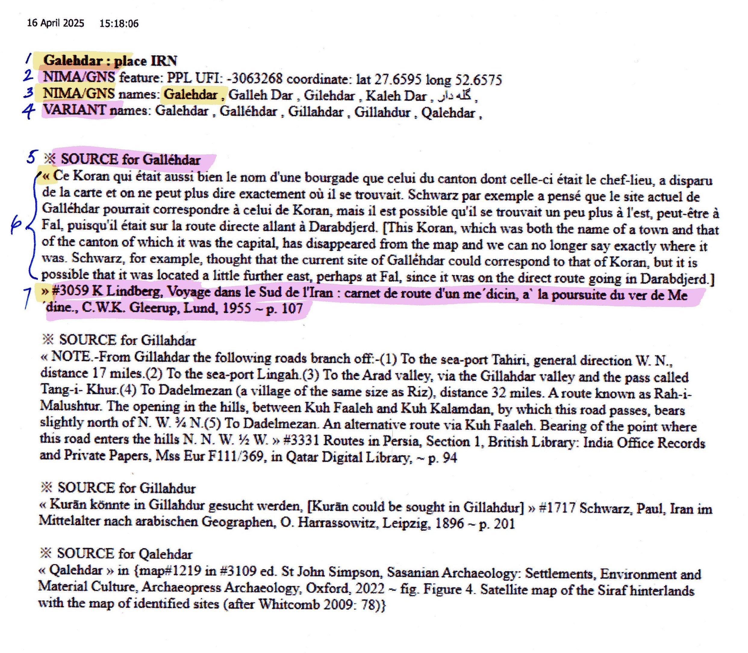
See highlighted image above:
Line 1 - Official place name selected from NIMA/GNS.
Line 2 - UFI Unique Feature Identifier and Coordinates.
Line 3 - Alternate or Variant Names given in NIMA/GNS
Line 4 - Additional Variant Names found in the text of a book, map, research paper or elsewhere.
Line 5 - SOURCE details for the names in line 4
Line 6 - Between " " is an extract from the source of the book (et al) containing the Place name, and translation to english between [ ].
Line 7 - Reference to the book (et al) #3059 being my book ID.