Not surprisingly for a place that reached its
zenith in the
16th century there are few images of the island, city or fort of Hormuz
and
even less for the original city of Hormuz, old Hormuz, on the mainland
near to
the present village of Minab. This study is therefore an attempt to
group
together all the images of Hormuz that I am aware of.
There are 2 main references, Luís Silveira's Ensaio
de
iconografia das cidades portuguesas do Ultramar[1]
[assay of iconography of the overseas Portuguese cities] published in
1955 and
Armando F. Cortesão's, Portugaliae Monumenta Cartographica [PMC][2],
an important and scholarly cartography reference illustrated with many
rare and
interesting Portuguese maps and charts published in 1960 and again in
1987.
Then there are some critical comments by Jean Aubin in his study of
Hormuz, Le
royaume d'Ormuz au début du XVIe siècle[3]
and some excellent articles and useful notes by C. R. Boxer.
The images appear in maps, plans, in maps of the
format carte
à figures with oval views of cities across the top and figures down the
sides,
as cartouches or vignettes, early photographs, drawings, paintings and
as
illustrations in books. The period is from the earliest known, that of
the
image of the arrival of the boat at old Hormuz, to early twentieth
century
photographs of the ruins of Hormuz fortress and the addition of some
archaeological plans of the 1970's. Many of the images are derived from
others
and some are straight imitations so the images have been grouped
together where
this is clearly evident to show the changes over time.
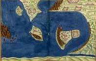
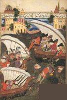
Marco Polo with elephants and
camels arriving at Hormuz on Gulf of Persia from India
Date:
c.1410-12
Book/Map:
Medieval miniature from the
book "The Travels of Marco Polo" ("Il milione" or "Le Livre des
Merveilles (The Book of Wonders)"
Artist/Engraver:
Boucicaut Master
Original source:
Ms Fr 2810 f.14v Bibliothèque
Nationale, Paris
Reproduced:
frequently reprinted
Image ref:
[487] 38966.jpg
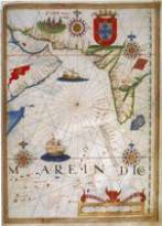
2.3C. 1519 REINEL,
PEDRO, REINEL, JORGE
& DE HOLANDA, ANTÓNIO
Title:
Indian Ocean
Date:
c. 1519
Book/Map:
chart no. 6, "Atlas Miller"
Artist/Engraver:
Reinel, Pedro, Reinel, Jorge
& de Holanda, António [illustrator]
Original source:
Collection Marcel Destombes, Rés.
Ge. DD. 683 Bibliothèque Nationale, Paris
Reproduced:
#1939 Couto, Dejanirah, Bacqué-Grammont,
Jean-Louis, and Taleghani, Mahmoud (eds.), Atlas historique du golfe
Persique (XVIe-XVIIIe siècles), Turnhout, Brepols, 2006~pp. 88-91
Referenced:
#1939 Couto, Dejanirah, Bacqué-Grammont,
Jean-Louis, and Taleghani, Mahmoud (eds.), Atlas historique du golfe
Persique (XVIe-XVIIIe siècles), Turnhout, Brepols, 2006~pp. 88-91
Image ref:
L. [507]
aramcomiller_enlarg.jpg R. [507] aramcomiller.jpg
Notes:
The image of Hormuz (aramuz)
is similar in styleto the feint image at
the entrance to the Gulf in Anonymous Portuguese [Pedro (?) Reinel],
[Chart of the Indian Ocean] c. 1510 #1939 pp. 78-9
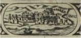
Gaspar Correia (c. 1495 -c. 1561) was a Portuguese historian and author of Lendas da
Índia,
one of the most important books on the Portuguese in the East. He was
in Ormuz
in 1515.[4]
His manuscript was not published till the end of the 19th
century by
order of the Class of Moral and Political Sciences and Belles Lettres
of the
Portuguese Academy of Sciences. This image appears in volume II which
covers 17
years ending 1526 and was first printed in 1861. However it is to be
noted that
Stanley in his introduction to his translation of Lendas da India
writes
"Miguel da Gama, son of D. Francisco, the second count of Vidigueira,
left
India on February 21st, 1583, bringing with him Correa's manuscript".[5]
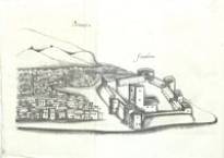
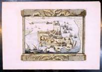
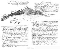
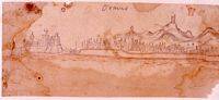
1541 ? Aubin disputes the
date that Silveira gives as circa 1529 saying that it shows the
fortress, the pilori of Albuquerque and the minaret, but confuses all
the remainder in diagrammatic lines and as the royal palace does not
appear there, the sketch must be after 1539-1540][6]
Book/Map:
Lendas da India
Artist/Engraver:
Gaspar Correia ?
Original source:
#1837 Correa, Gaspar, Lendas
da India, etc. [Edited by R. J. de Lima Felner. With plates.],
Typographia da Academia Real das Sciencias, 1858-64vol. 2 after p. 438
Reproduced:
#1838 Silveira, Luís, Ensaio
de iconografia das cidades portuguesas do Ultramar, Junta de
Investigações do Ultramar, 1955~ vol. 3
pl. 514 p. 324
Reproduced:
#1118 Cortesão, Armando F.
and Teixeira Da Mota, Avelino, Portugaliae Monumenta Cartographica,
Imprensa Nacional-Casa da Moeda, Lisboa, 1960: 1987~ vol. 1 p. 167-72 Plate 86 E
Referenced:
Silveira #514
Referenced:
PMC vol. VI p. 4 List 1 -
meados do século xvi, 11 desenhos panorâmicos in Lendas da Índia.
Arquivo Nacional da Torre do Tombo, Lisboa - I, 167-8, PI. 85-86.
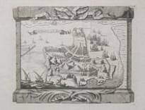
#1872 Archivo Pittoresco,
Lisboa, 1857-1868~ Tomo III pp. 281 1860
Reproduced:
#1838 Silveira, Luís, Ensaio
de iconografia das cidades portuguesas do Ultramar, Junta de
Investigações do Ultramar, 1955~ vol. 3
pl. 524 p. 328
Referenced:
Silveira #524
Notes:
Archivo Pittoresco was published in Lisbon
in 11 volumes between 1858 and 1868 by Vicente Jorge de Castro. At the
time it was considered to be a major exponent of wood engravings. The
publication of this image in Archivo Pittoresco occurs at the same as
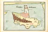
the manuscripts of Gaspar Correia are first published.
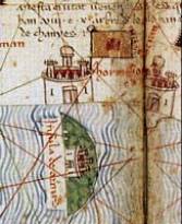
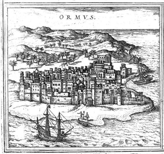
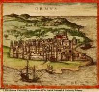
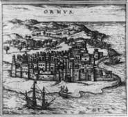
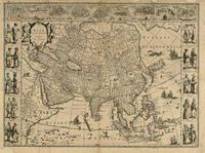
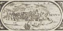
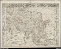
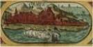
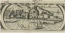
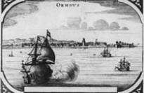
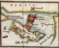
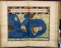
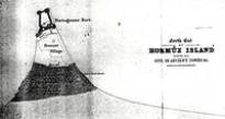
Figure
1 Ormus from Civitates
[RES. 504 A. Biblioteca Nacional de Portugal, ref1673cropOrmus.jpg]
City views date from the second half of the 15th
century but
it was not until the mid 16th century that they achieved the
popularity that came about with the publication of Civitates Orbis
Terrarum by
Frans Hogenberg and Georg Braun in1572
- 1618.[7]
In volume I of Civitates there is an image of Hormuz that became the
model for
many images in the decorative borders of maps throughout the 17th
century and after.Keuning states that
the engravers of Civitates were "Hogenberg and Van den Neuvel
(Novellanus)" and
"Some cities were depicted by the artists in person, pictures of other
cities
were received from people who visited them. To be mentioned with
praise, said
Bruin, was Georg Hoefnagel from Antwerp, who supplied him with pictures
of the
cities of Spain and of their inhabitants, very accurately drawn from
life."[8]
Dutch and Flemish views were copied from the drawings in the Atlas of
Jacques
de Deventer.[9]
Other artists associated with Hoefnagel who might have supplied views
for the
Civitates include Anton van den Wyngaerde[10]
and Lodewijk Toeput[11]
Unlike other prints in Civitates there are
no
signatures or text that may indicate the model for Ormus. Of Blaeu's
1608 wall
map of Asia[12],
"Almost two thirds of the views are based on Civitates, all originating
from
the first volume (1575). The source used by the compiler of the
Civitates can
be retraced only partially. About the sources for the descriptions of
Aden,
Ormus, Candy and Calicut we still have no information. In his foreword
Georg
Braun pays special thanks to the merchant Constantin von Lyskirchen for
previously unpublished depictions of towns in Asia, Africa and Persia,
accompanied by their handwritten descriptions. We can speculate that a
Portuguese manuscript was put at Braun's disposal by von Lyskirchen.
This
manuscript, which has not survived, must have been similar to the
Lendas da
India, by Gaspar Correia or the Livro de Lizarte de Abreu, both of
which had
been completed before 1564."[13]
As stated above Correa's manuscript did not leave India till 1583 and
the Livro
de Lizarte de Abreu does not contain any illustrations of Hormuz. The
only
other reference I can find of von Lyskirchen is by Norwich "in the
Hanse
merchant Constantin von Lyskirchen of Cologne the editors found a
willing
agent, who supplied views of the towns of India, Asia, Africa, and
Persia never
portrayed before . Lyskirchen obtained these views from the manuscript
produced
by an unknown Portuguese illustrator .apart from these Portuguese
views, some
of the African illustrations were taken from military plans concerned
with the
expeditions of the Emperor Charles V in 1535 and 1541 to Tunis and
Algeria."[14]
Also to be considered is that Braun, born in Cologne, became a Catholic
priest
and held the post of tutor to the son of the Cologne merchant Heinrich
Sudermann from about 1565 to 1577, and it was while in Sudermann's
employ that
Braun began work on the Civitates orbis terrarum, using the merchant's
broad
range of commercial contacts. Constantin von Lyskirchen (d. 1581) was a
friend
of Heinrich Sudermann.
We should consider the view of Aden in Civitates
and the
"copy of a large Flemish woodcut (from which Hogenberg may well have
borrowed
details) representing the unsuccessful Portuguese assault on the city
in 1513."[15]
Although Afonso de Albuquerque attacked Aden in February 1513, he was
unable to
take it through lack of ladders and fresh water and in February 1515
returned
to Ormuz where he finally obtained possession of Hormuz and began the
restoration of the Portuguese fort.[16]
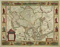
Numerous maps used the city views from Williem
Jansz's 1608
wall map: the city views in Asia by Pieter van den Keere (1614 Map 20)
are from
Williem Jansz 1608 wall map of Asia[17];
the decorative strips in Asia by Williem Jansz (1617 Map 21) are based
entirely
on the border decorations from Blaeu's 1608 wall map of Asia[18];
Blaeu's 1617 map served Jodocus Hondius as models in his Asia (1619 Map
22)
while added views of Famagusta, Rodus and Gammalamme were copied from
Blaeu's
1608 wall map of Asia[19];
the city views in Asia, by Jodocus Hondius, (1623 Map 23) are identical
to
Hondius's 1619 map[20];
the city views in Asia by Frederik de Wit (1660 Map 24) were copied
from the
top border of JodocusHondius's map of
Asia (Map 23).[21]
Map Collections Maps C.25.b.13. [Another
impression.] (In Illustriorum Hispaniae Urbium Tabulae, etc. Fol. Y.)
[1600.] fol ,British Library
Reproduced:
#1838 Silveira, Luís, Ensaio
de iconografia das cidades portuguesas do Ultramar, Junta de
Investigações do Ultramar, 1955~ vol. 3
pl. 516 p. 325
Reproduced:
frequently reprinted
Referenced:
Silveira #516
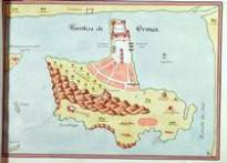
Notes:
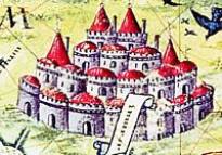
The plate gives a stylised view of Hormuz.
The town and the wind towers are prominent but there does not appear to
be any indication of the fort. Braun-Hogenberg's
Civitates Orbis Terrarum was the first general collection devoted
solely to topographical views.[22]
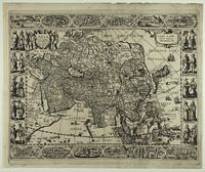
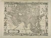
Asia with the islands
adioyning described, the atire of the people & townes of
importance, all of them newly augmented by I.S. Ano dom. 1626 /
Sculptum apud Abrahamum Goos
Artist/Engraver:
John Speed
City Views:
TOP 5/8 Candy, Goa, Damascus,
Jerusalem, Ormus, Bantam, Aden and Macao.
Original source:
First Edition of John Speed's
Prospect of the Most Famous Parts of the World, published by George
Humble, 1626
The poet Daniel Meisner from Komotau started
his Thesaurus Philo-Politicus, Das ist Politisches Schatzkästlein guter
Herren und bestendiger Freund... in Frankfurt in 1623, initially in
parts, each one containing about fifty plans. The work was printed work
and was printed by Eberhard Kieser.
Title:
Ormus in Persia
Date:
1638
Book/Map:
Thesaurus philo-politicus.
Artist/Engraver:
Daniel MEISNER Imprint:
Frankfurt, 1638
Original source:
#1878 Meisner, Daniel,
Thesaurus philo-politicus, das ist: Politisches Schatzkästlein guter
Herzen und bestendiger Freund, Frankfurt, 1623~
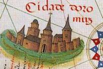
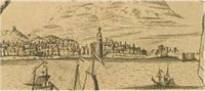
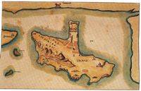
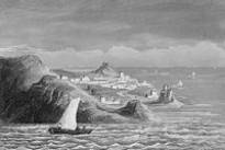
From the "Braun style" image there emerged a more
realistic
view of the island seen from the north with the Portuguese fort to the
right
and the town stretching out to the left around the bay. Accurate in the
form of
the fort layout, particularly the buttresses, the open ground between
the fort
and the houses and the minaret in the centre. This image first appeared
in 1629
and continued to be used till at least 1729, as detailed below left.
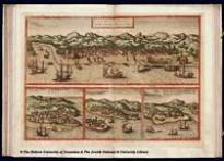
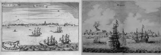
Figure
2 Ormus [464] and Makou
[517].
The above right image
illustrates
Makou (Macao) in Johannes Nieuhof's, L'Ambassade de la Compagnie
Orientale
des Provinces Unies vers l'Empereur de la Chine ...[23]
and Het Gezantschap der Neêrlandtsche Oost-Indische Compagnie aan
den
grooten Tartarischen Cham den tegenwoordigen Keizer van China, waarin
de ...[24],
both published in 1665. The artist has flattened the perspective of
Makou and
increased the size of the ships to make them the focal point rather
than the
city in which only the minaret and the structure emitting smoke on top
of the
hill to the left have been amended.
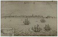
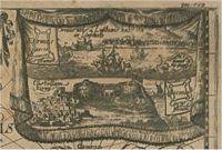
Ormous, Het Eylandt Ormous,
en Gomeron, op t vaste landt van Persiën
Date:
1629
Artist/Engraver:
Anonymous
Original source:
Rijksmuseum Amsterdam
inventory no. RP-P-OB-75-464 with the note "According to the index of
'Begin ende Voortgang', the illustration is entitled: <Het Eylandt
Ormous, en Gomeron, op t vaste landt van Persiën.>"
Notes:
[#1866 Commelin, Isaac, Begin
ende voortgangh, van de Vereenighde Nederlantsche Goectroyeerde
Oost-Indische Compagnie. Vervatende de voornaemste reysen, by de
inwoonderen der selver provincien derwaerts gedaen ..., Amsterdam :
Theatrum Orbis Terrarum, 1646:1969 2 v. in 4~
I was unable to locate this engraving in any of the 4 vols of the 1969
edition]
Het Eylandt ORMOUS, en
GOMERON, op 'tvaʃte landt van Perſien
Date:
1629
Book/Map:
Pieter van den Broecke in Azië. (Journalen.)
Artist/Engraver:
Pieter van den Broecke ?
Original source:
#1840 Broecke, Pieter van den, Pieter van
den Broecke in Azië. (Journalen.) Uitgegeven door ... W. Ph. Coolhaas,
etc. [With plates, including a portrait, a facsimile and maps.], 1962~ after p. 352
Notes:
engraving (b/w) from the journals of Pieter
van den Broecke of the VOC. Pieter van den Broecke (1585-1640) was a
Dutch official in the service of the Dutch East India Company (VOC) and
produced numerous drawings.
[Illustrations de Recueil de
voiages] / [Non identifié] ; René Augustin Constantin de Renneville,
aut. du texte.[Tome IX (5). Pl. dépl. en
reg. p.163 :] Ormus. [Cote : Réserve A 200 119 v1 à v7] BNF, Paris
Reproduced:
#1886 de Renneville, René
Augustin Constantin, Recueil des voyages qui ont servi à
l'établissement et aux progrès de la Compagnie des Indes Orientales,
formée dans les Provinces Unies des Païs-bas, Amsterdam, 1702~
Reproduced:
#1885 A Collection of Voyages
undertaken by the Dutch East-India Company, for the Improvement of
Trade and Navigation ... Together with an historical introduction,
giving an account of the rise, establishment and progress of that great
body ... Illustrated with several charts., W. Freeman, London, 1703~A translation
of the first volume of the "Recueil des voyages, etc."[#1886], itself a
translation and adaptation by R. A. C. de Renneville, under the
pseudonym "De Constantin", of Isaak Commelin's "Begin ende voortgangh
van de Vereenighde Nederlandtsche Geoctroyeerde Oost-Indische
Compagnie".
tav. [5a], N. IX 26 - Vol. 18
- Tomo 52, Biblioteca Casanatense - Roma
Reproduced:
#1904 Aa, Pieter van der, La
Galérie Agréable du Monde, où l'on voit en un grand nombre de cartes
très exactes, et de belles tailles-douces, les principaux empires,
royaumes, républiques, provinces, villes, bourgs et forteresses ...
dans les quatre parties de l'univers; divisée en LXVI. tomes. Les
estampes aiant été dessinées sur les lieux, et gravées ... par ...
Luyken, Mulder, Goerée, Baptist, Stopendaal et par d'autres maitres
renomez ... Le tout mis en ordre et executé ... par P. van der Aa.,
Leiden, 1729~
#1118 Cortesão, Armando F. and Teixeira Da
Mota, Avelino, Portugaliae Monumenta Cartographica, Imprensa
Nacional-Casa da Moeda, Lisboa, 1960: 1987~
vol IV Plate 420 Item C
#1118 Cortesão, Armando F. and Teixeira Da
Mota, Avelino, Portugaliae Monumenta Cartographica, Imprensa
Nacional-Casa da Moeda, Lisboa, 1960: 1987~
vol V Plate 582 Item E
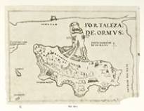
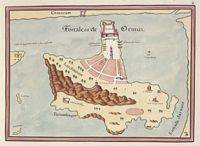
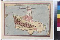
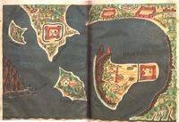
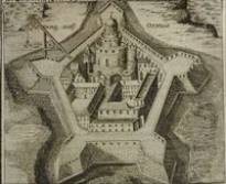
Plans of ports, islands, and
straits of the Red Sea, East Asia, and Philippines
Date:
1630
Book/Map:
The13th
map in Taboas geraes de toda a navegação / divididas e emendadas por
Dom Ieronimo de Attayde com todos os portos principaes das conquistas
de Portugal delineadas por Ioão Teixeira cosmographo de Sua Magestade,
anno de 1630
Artist/Engraver:
Albernaz I, João Teixeira
Original source:
Library of Congress Geography
and Map Division Washington, D.C., CALL NUMBER G1015 .T4 1630 Vault
DIGITAL ID g3200m gct00052
Reproduced:
#1118 Cortesão, Armando F. and Teixeira Da
Mota, Avelino, Portugaliae Monumenta Cartographica, Imprensa
Nacional-Casa da Moeda, Lisboa, 1960: 1987~
vol IV Plate 472 Item C as Atlas de trina e una cartas (Atlas of 31
charts).
Referenced:
PMC vol. VI pp.1-2 List 5 -
1630, atlas universal, com 31 cartas. Library of Congress, Washington
(Atlas 5931) - IV, 111-8, PI. 464-472.
Notes:
João Teixeira Albernaz (1575 ? - 1662 ?),
also known as João Teixeira Albernaz I was a prodigious Portuguese
cartographer.
PMC vol. VI pp.1-2 List *24 -
c. 1648, atlas das cidades e fortalezas do Oriente, com 23 cartas.
Bayerische Staatsbibliothek, München (Cod. Mon. Icon. 162) -IV, 145,
PI. 511-512; V, 186
Österreichische Nationalbibliothek, Cod.5958
fol.3(:Fortaleza de Ormus) Katalogzettelnummer: #380630 (S:S)
Referenced:
PMC vol. VI pp.1-2 List *25 -
c. 1648, atlas das cidades e fortalezas do Oriente, com 23 cartas.
Õsterreichische Nationalbibliothek, Wien (Codex 5958) - IV, 145, V, 186.
Österreichische Nationalbibliothek, Cod.
6.860 fol.3 (recte 4). (:Ormus. Pland der Dnsel, Stadt und Festung.
Farbige Handzeichnung um 1600.) Katalogzettelnummer: #380773 (S:S)
Reproduced:
#1873 Quelle, Otto, Portugiesische
Manuskriptatlanten, Verlag von Dietrich Reiner, 1953 Abhandlungen des
Geographischen Instituts der Freien Universität Berlin; Band II~Tafel XV (from Codex 6860)
Reproduced:
#1838 Silveira, Luís, Ensaio
de iconografia das cidades portuguesas do Ultramar, Junta de
Investigações do Ultramar, 1955~ vol. 3
pl. 518 p. 326 (from Quelle Codex 6860)
Referenced:
Silveira #518
Referenced:
PMC vol. VI pp.1-2 List *26 -
c. 1648, atlas das cidades e fortalezas do Oriente, com 23 cartas.
Õsterreichische Nationalbibliothek, Wien (Codex 6860) - IV, 145, V, 186.
PMC vol. VI pp.1-2 List *27c. 1648, atlas das cidades e fortalezas do
Oriente, com 23 cartas. Bibliothèque Nationale, Paris (Rés. Ge. DD.
2013) IV, 145, V, 186.
MS 439 & MS 440: Two
Seventeenth-Century Portuguese Atlases In The Library Of The Queen's
College, Oxfordarticle 5 May 2009
Veronika Vernier, Historic Collections Assistant
Silveira states that the images come from
the codex n.° 1471 in the library of the Paço Ducal de Vila Viçosa
Reproduced:
#1661 Silveira, Luís, Livro
das plantas das fortalezas, cidades e povoações do Estado da India
Oriental com as descrições do marítimo dos reinos e províncias onde
estão situadas e outros portos principais daquelas artes :
contribuição para a história das fortalezas dos portugueses no
ultramar / edição preparada e prefaciada por Luís Silveira,
Ministério do Planeamento e da Administração do Território,
Instituto de Investigação Científica Tropical, Lisboa, 1991 ~plate 39 p. 55
Reproduced:
#1838 Silveira, Luís, Ensaio
de iconografia das cidades portuguesas do Ultramar, Junta de
Investigações do Ultramar, 1955~ vol. 3
pl. 517 p. 325
Referenced:
Silveira #517
Referenced:
PMC vol. VI pp.11-12 List 43
- c. 1650, 104 cartas in Livro das Plantas das Fortalezas, Cidades e
Povoações do Estado da índia Oriental... Biblioteca do Palácio Ducal da
Casa de Bragança, Vila Viçosa (1471) - V, 73-6, PI. 388, 576-578, e 580.
Image ref:
[431] ref1661p55.jpg
Notes:
Silveira states in his preface p. III:
"Canal of the Conceição de N. Mrs.
descuberto anno of 1633 for P.° Bertolo". This "P.° Bertolo" must be
the Frenchman Pierre Berthelot [or Bertolot], pilot and cartographer,
who left for Asia in 1619 and who died at Achéns in 1638.This letter,
therefore, is credible that it has been drawn not much later of 1633.
#811 Faria E Sousa, Manuel
De, Ásia Portuguesa, Lisbon, 1674~ vol. 1
Reproduced:
#1838 Silveira, Luís, Ensaio
de iconografia das cidades portuguesas do Ultramar, Junta de
Investigações do Ultramar, 1955~ vol. 3
pl. 519 p. 326
Referenced:
Silveira #519
Referenced:
PMC vol. VI pp.11-12 List 49-
1666-1675, 18 cartas gravadas de povoações e fortalezasdoOriente, inÁsia Portuguesa de Manuel de Faria e
Sousa - V, 79, PI. 582, 585 e 586.
Histoire des découvertes et conquestes des
Portugais dans le Nouveau monde
Original source:
#1841 Lafitau, Joseph-François, Histoire des
découvertes et conquestes des Portugais dans le Nouveau monde,
Saugrain pere [etc.], 1733~ vol. 1
between pp. 520 and 521
Reproduced:
#624 Grande Enciclopédia Portuguesa E
Brasileira, Editorial Enciclopedia, LDA, Lisbon, 1945 (?)~
Reproduced:
#1838 Silveira, Luís, Ensaio
de iconografia das cidades portuguesas do Ultramar, Junta de
Investigações do Ultramar, 1955~ vol. 3
pl. 520 p. 327
Referenced:
Silveira #520
Image ref:
[435]
ref1841vol1afterp.520_G.jpg
Notes:
An engraving with the image of Albuquerque
and a view of the city of Hormuz.
Histoire générale des Voyages, ou nouvelle
collection de toutes les relations de voyages par mer et par terre qui
ont été publiées jusqu'à présent dans les différentes langues de
toutes les nations connues. Enrichi de cartes géographiques, ... de
plans
Artist/Engraver:
Original source:
#1836 Prévost d'Exiles,
Antoine François [Abbé], Histoire générale des Voyages, ou nouvelle
collection de toutes les relations de voyages par mer et par terre qui
ont été publiées jusqu'à présent dans les différentes langues de
toutes les nations connues. Enrichi de cartes géographiques, ... de
plans, Chez Didot, Paris, 1746-70~
Reproduced:
Antoine-François Prevosts 20 volume edition
of L`Histoire Generale des Voyages published by Pierre de Hondt, The
Hague in 1747-80.
Reproduced:
#1838 Silveira, Luís, Ensaio
de iconografia das cidades portuguesas do Ultramar, Junta de
Investigações do Ultramar, 1955~ vol. 3
pl. 521 p. 327
#1836 Prévost d'Exiles, Antoine François
[Abbé], Histoire générale des Voyages, ou nouvelle collection de
toutes les relations de voyages par mer et par terre qui ont été
publiées jusqu'à présent dans les différentes langues de toutes les
nations connues. Enrichi de cartes géographiques, ... de plans, Chez
Didot, Paris, 1746-70~
Notes:
A bird's eye view (colour) from Prévost's L'Histoire
Général des Voyages, a publication that was issued a number of
times in Paris between 1747 and 1770. The maps were provided by Jacques
Bellin, who was the first 'Ingénieur hydrographe de la Marine" in
France.
British Library, London Ms.
Sloane 197, f.155 v/156
Reproduced:
#41 Albuquerque, Afonso de,
The Commentaries of the Great Affonso De Albuquerque - 1500-1580 The
Second Viceroy of India. Translated from the Portuguese edition of
1774, with notes and an introduction, by W. de G. Birch., Hakluyt
Society:Asian Educational Services, London:New Delhi, 1875-94:2000~ vol. 1 after p. 112 note British Museum,
Sloane MS. 197, fo. 156.
Reproduced:
in PMC#1118
Cortesão, Armando F. and Teixeira Da Mota, Avelino, Portugaliae
Monumenta Cartographica, Imprensa Nacional-Casa da Moeda, Lisboa, 1960:
1987~ vol. V Plate 582 item G
Referenced:
PMC vol. VI pp. 8-9 List 3 -
1646, 66 cartas in Livro do Estado da índia Oriental. British Museum,
London (Sloane MS 197) - V, 67-70, PI. 580, 582, 586 e 588-590.
Rtrftro. Dmr. n - T 87-04
Notes:
Antonio Bocarro (1594 ? - 1642 ) .[25]
Pedro Barreto de Resende (1590 ? - 1640 ?) was a Portuguese
cartographer. Although not attributed in the book, he is the author of
the illustrations in the "Livro do Estado da India Oriental" by António
Bocarro (1635) (British Library, Sloane Ms. 197), this attribution
being confirmed in another similar codex, "Descrições das Fortalezas da
Índia Oriental" (F.P ms. nº 1, Bibliothèque nationale de France)
Bibliothèque nationale de France, Paris, Ms. F.Portugais ms. nº 1, fol.147v-148
Reproduced:
#1876 Albuquerque, Luís de,
and Francisco Contente Domingues, eds., Dicionário de história dos
descobrimentos portugueses, Caminho, Lisboa, 1994~
Volume 2 page 835 bottom lefthas a small
image of Ormuz with the title "Ormuz (codice 1889 da Biblioteca
Casanatense, de Roma)" this is incorrectly attributed.
Referenced:
#1930 Morel-Fatio, Alfred,
Bibliothèque nationale. Département des manuscrits. Catalogue des
manuscrits espagnols et des manuscrits portugais, Imprimerie nationale,
Paris, 1892~ No 50 pp.324-5
Referenced:
PMC vol. VI pp. 11-12 - 1636,
70 cartas in Livro do Estado da India Oriental de Pedro Barreto de
Resende. Bibliothèque Nationale, Paris (Mss. Portugais, n. ° 1) - V,
66-7, PI. 579, 583-587 e 589-591
Notes:
Pedro Barreto de Resende (1590 ? - 1640 ?)
is the author of the illustrations, this attribution being confirmed in
the codex, "Descrições das Fortalezas da Índia Oriental" (F.P ms. nº 1,
Bibliothèque nationale de France)
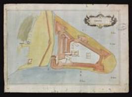
"Pure ichnographic plans, that is ground-plans
drawn to a
consistent scale as preferred in most contexts today, were rare in this
period.
Examples such as Leonardo da Vinci's ichnographic plan of Imola in the
Royal
Library in Windsor and Bufalini's plan of Rome are exceptions. In
general,
ichnographic plans were employed for architectural and urban planning,
administration and warfare. In the fifteenth and sixteenth centuries,
chorographies in the narrow sense of the term used here, tended to
depict
cities."[26]
Plantas de praças das
conquistas de Portugal : feytas por ordem de Ruy Lourenço de Tavora
Vizo rey da India
Artist/Engraver:
Manuel Godinho de Erédia
Original source:
Objeto Digital: cart990145,
Fundação Biblioteca Nacional, Rio de Janeiro, Brazil
Reproduced:
Atlas of Manuel Godinho de
Heredia (Eredia) Cota: Arquivo Histórico Militar Pasta 25.
Reproduced:
#1838 Silveira, Luís, Ensaio
de iconografia das cidades portuguesas do Ultramar, Junta de
Investigações do Ultramar, 1955~ vol. 3
pl. 515 p. 324
Referenced:
Silveira #515
Referenced:
PMC vol. VI p. 5 List 3 -
1610, atlas com 20 plantas de fortalezas do Oriente. Biblioteca
Nacional, Rio de Janeiro (CAM-3, 5) -IV, 48, PI. 411 D-F.
Notes:
Manuel Godinho de Eredia (1563 - 1623)[27]
is mainly associated with the Far East in particular Malacca and
Australia although he evidently dedicated a book "Historia do Martyrio
de Luiz Monteiro Coutinho que padeceo por ordem do Rey Achem Raiamancor
no anno de 1588, e dedicada ao illustrissimo D. Aleixo de Mcnezes,
Arcebispo de Braga"[28]in Goa dated 11th November 1615.
"The earliest known plan,
from the Adas of ManuelGodinho de
Heredia, in Rio de Janeiro, dates from 1610 andshould
be compared with Joao Teixeira's drawing in the Vienna Library." #931
Boxer, C.R. and De Azevedo, C., Fort Jesus And The Portuguese In
Mombasa, London, 1960~ p. 102
#1335 Foster, William, A View of Ormus in
1627, The Geographical Journal, London, 1894 (Aug.) 4:2:160-2 ~
Notes:
. an ancient sketch-map of Bombay harbour,
which was found a few years ago in one of the logs of the East India
Company's vessels, .. This drawing attracted considerable attention at
the time of its publication, .. We are now enabled, by the permission
of the anthorities, to give a facsimile of a second sketch from the
same journal, representing the once famous town and castle of Ormus, as
they appeared in the year 1627. the author of our sketch - David
Davies, master's mate of the East India Company's ship Discovery.
#1696 HENRION, Mathieu
Richard Auguste, Baron, Histoire générale des missions catholiques
depuis le xiiie siècle jusqu'à nos jours, Paris, 1846~ vol. 2 p. 482 plate lxi
Image ref:
[26] 10007488.jpg
7.41648 UNKNOWN
Title:
Ormus
Date:
1648
Book/Map:
Des HochEdelgebornen Johan
Albrechts von Mandelslo Morgenländische Reyse-Beschreibung
Reproduced:
#1891 Voyages célèbres
& remarquables, faits de Perse aux Indes orientales, par le Sr. J.
A. de Mandelslo ... Traduits de l'original par le Sr. A. de Wicquefort,
etc., M. C. le Cène, Amsterdam, 1727~
Original source:
#1992 Mandelslo, Johan
Albrecht von, Des HochEdelgebornen Johan Albrechts von Mandelslo
Morgenländische Reyse-Beschreibung, Hamburg, 1658~
p. 33
#1470 Kaempfer, Engelbert,
Amoenitatum exoticarum politico-physico-medicarum fasciculi V : quibus
continentur variae relationes, observationes & descriptiones rerum
Persicarum & Ulterioris Asiae / multâ attentione, in
peregrinationibus per universum Orientem collectae, ab auctore
Engelberto Kaempfero., Typis & Impensis Henrici Wilhelmi Meyeri .,
1712~ p. 764
Image ref:
[438] ref1470p.764.jpg
Notes:
Ormus and Kismis. The vignette of Ormus has
the inscription Ormus urbs á Lusʃitanis habitata ex Linʃchoto and a
plan of the island Inʃ. plan.
#1185 Buckingham, J. S.,
Travels in Assyria, Media, and Persia, including a journey from Bagdad
by Mount Zagros, to Hamadan, the ancient Ecbatana, researches in
Ispahan and the ruins of Persepolis, and journey from thence by Shiraz
and Shapoor to the sea-shore, Henry Colburn: Gregg International
Publishers Limited, London: London, 1829:1971~
p. 428
Artist/Engraver:
J. Dodd of 50 Aldersgate Street. Saint
Martins (1819R-1835)
Notes:
J. S. Buckingham (1786-1855) author and
traveller, founder of the Calcutta Journal, the Oriental Herald and
Colonial Review, The Sphynx, and The Argus, social reformer, and
founder member of the British and Foreign Institute, travelled in the
Middle East as a sea captain and merchant.
Image ref:
[445] ref1185p428_IA.jpg
7.81713? PICART
Title:
Les isles d'Ormus, Lareke et
Kismis
Date:
1713?
Book/Map:
Volume II. Voyage par la
Moscovie, en Perse et aux Indes orientales. Pl. dépl. en reg. p.322 :
Perse.] Gamron. Les isles d'Ormus, Lareke et Kismis. [Cote : Réserve A
200 294 v1 v2] [#1892 Bruyn, Kornelis Philander de, Voyages de
Corneille Le Brun par la Moscovie, en Perse et aux Indes orientales
..., Chez les Frères Wetstein, 1718~]
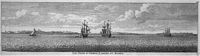
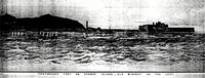
#938 Danvers, F. C., The Portugese In India:
Being a History of the Rise and Decline of Their Eastern Empire, Asian
Educational Services, London: New Delhi, 1894: 2003~ vol.1 after p.330 note: Fort Of Ormuz
from a painting by Captain Arthur W. Stiffe, late, R.I.M., specially
lent for this work
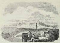
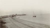
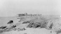
Rev. S. M. Zwemer was a member of the
Arabian Mission (1890-1913) to the Persian Gulf based in Basra. He made
a number of journeys in the area and in particular "Three journeys in
northern Oman" [30]
around 1900-1901.
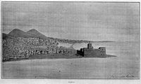
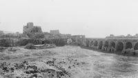
from on top of the southern wall towards the
north wall
Date:
1932-3 [#831 Stein, Sir M.
Aurel, Archaeological Reconnaissances in Southern Persia, The
Geographical Journal, London, 1934 (Feb) 83:2:119-34 ~ p. 119]
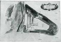
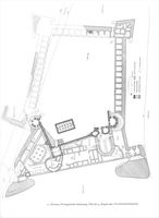
Hormoz, Portugiesische
Seefestung, Plan der 4. Bauperiode (Gesamtaufnahmeplan)
Date:
1978
Artist/Engraver/Photographer:
Kleiss, Wolfram
Original source:
#301 Kleiss, Wolfram, Die portugiesische
Seefestung auf der Insel Hormuz am Persischen Golf (The Portuguese
fortress on the island of Hormuz in the Persian Gulf), Architectura,
Munich, 1978 8:166-183 ~
Image ref:
[491] ref301pl12p175ph3.jpg
[1]
#1838 Silveira, Luís, Ensaio de iconografia das cidades portuguesas do
Ultramar, Junta de Investigações do Ultramar, 1955~
[2]
#1118 Cortesão, Armando F. and Teixeira Da Mota, Avelino, Portugaliae
Monumenta
Cartographica, Imprensa Nacional-Casa da Moeda, Lisboa, 1960: 1987~
[3]
#898 Aubin, Jean, Le royaume d'Ormuz au début du XVIe siècle, Mare
Luso-Indicum,
Geneva, 1973 2:IV/5:77-237 ~ particularly pp. 83-90
[4]
#898 Aubin, Jean, the kingdom of Ormuz at the beginning of XVIe
century,
Luso-Indicum Pond, Geneva, 1973 ~ p. 157
[5]
#1865 Stanley, Henry E. J., The three voyages of Vasco de Gama, and his
viceroyalty : from the Lendas da India of Gaspar Corrêa, Burt Franklin,
New
York, 1869~ Introduction p. ii
[6]
#898 Aubin, Jean, the kingdom of Ormuz at the beginning of XVIe
century,
Luso-Indicum Pond, Geneva, 1973 ~ notes p. 83
[7]
#1909 Bennett, Shirley K., Art on Netherlandish maps, 1585-1685: Themes
and
sources, University of Maryland College Park, 1990~ p. 135 and #1966 Keuning, Johannes, The "Civitates"
of Braun and Hogenberg, Imago Mundi, 1963 17:41-4 ~
[8]
#1966 Keuning, Johannes, The "Civitates" of Braun and Hogenberg,
Imago Mundi, 1963 17:41-4 ~ p.42
[10]
#1979 Haverkamp-Begemann, Egbert, The Spanish Views of Anton van den
Wyngaerde,
Master Drawings, 1969 (Winter) ~
[11]
#1976 Gerszi, Teréz, The Draughtsmanship of Lodewijk Toeput, Master
Drawings,
1992 (winter) ~p. 374
[12]
"Josua van den Ende's task was to engrave the map image of Williem
Jansz's 1608
wall map of the four continents and Hessel Gerritz ( 1580/81-1632) was
responsible for etching the decorative borders and other decorative
details.
Comparison with other work by Hessel Gerritz suggests that he etched
the
cartouches and ornamental aspects of the map, as well as the decorative
borders" #1906 Schilder, Günter, Monumenta Cartographica Neerlandica,
Alphen aan den Rijn : Canaletto, 1986~
Vol. V p. 91
[13]
#1906 Schilder, Günter, Monumenta Cartographica Neerlandica, Alphen
aan
den Rijn : Canaletto, 1986~ Vol. V p.
132
[14]
#1965 Norwich, Oscar I., Norwich's maps of Africa : an illustrated and
annotated carto-bibliography, Terra Nova Press, 1997~ p. 380
[15]
#1975 Skelton, R. A., Colonial Exhibition, British Museum, The
Burlington
Magazine, 1949 (Sep.) 91:558:253 ~ p. 253 which does not have
illustrations but
these cab be compared in #1968 Norris, H. T. & Penhey, F. W., The
Historical Development of Aden's Defences, The Geographical Journal,
London,
1955 (Mar.) 121:1:11-20 ~ between pp. 16 and 17. Another illustration
of the
Flemish wood engraving is in #1103 Marco Polo and Rustichello of Pisa,
The
Travels of Marco Polo: The Complete Yule-Cordier Edition, Dover
Publications
inc., New York, 1993 2 vols~ vol II p.
440. The original copy in the BL is catalogued Title: Aden Dese
machtege eñ
grote stat Adẽ genoemt ... bestormt eñ beuochtẽ vã
Alfonso Dalburkerke ... op dẽ heiligẽ paeschauõt int iaer õs
heerẽ ih̃u cristi als me screef MCCCCCXIII. [1 ft. 7 in. x 3 ft. 6
1/2 in]Publisher/year: [Antwerp],
[1513]
[16]
#72 Livermore, H. V., A History of Portugal, Cambridge University
Press,
Cambridge, England, 1947 ~ p. 235
[17]#1906
Schilder, Günter, Monumenta Cartographica Neerlandica, Alphen aan den
Rijn : Canaletto, 1986~ Vol. VI
p.144
[18]#1906
Schilder, Günter, Monumenta Cartographica Neerlandica, Alphen aan den
Rijn : Canaletto, 1986~ Vol. VI
p.148
[19]#1906
Schilder, Günter, Monumenta Cartographica Neerlandica, Alphen aan den
Rijn : Canaletto, 1986~ Vol. VI
p.151
[20]#1906
Schilder, Günter, Monumenta Cartographica Neerlandica, Alphen aan den
Rijn : Canaletto, 1986~ Vol. VI
p.153
[21]#1906
Schilder, Günter, Monumenta Cartographica Neerlandica, Alphen aan den
Rijn : Canaletto, 1986~ Vol. VI
p.157
[22]
#1896 Tooley, R.V., Maps and Map-Makers, Batsford, 1978~ p.26
[23]
#1934 Nieuhof, Johannes, L'Ambassade de la Compagnie Orientale des
Provinces
Unies vers l'Empereur de la Chine ... faite par les Srs P. de Goyen et
J. de
Keyser ... Le tout recueilli par Nieuhoff ... mis en François par J.
L.
Carpentier., J. de Meurs, Leyde, 1665~
opp p. 60.
[24]
#1937 Nieuhof, Johannes, Het Gezantschap der Neêrlandtsche
Oost-Indische
Compagnie aan den grooten Tartarischen Cham den tegenwoordigen Keizer
van
China, waarin de ... Geschiedenissen die onder het reizen door de
Sincesche
Landtschappen ... sedert den jare 1655 tot 1657 zijn voorgevallen ...
verhandelt worden, etc. [Edited by H. Nieuhof.], 1665~ between pp. 34 and 35.
[25]
In #931 Boxer, C.R. and De Azevedo, C., Fort Jesus And The Portuguese
In
Mombasa, London, 1960~ notes 1, p.
128, Boxer states << 1. From the "Livro do Estado da India
Oriental"
(British Museum, Sloane Ms. 197, fls. 105-6). This work is basically by
Antonio
Bocarro with minor corrections by Pedro Barreto de Rezende, as
explained in C.
R. Boxer, "Antonio Bocarro and the Livro do Estado da India
Oriental", reprinted from Garcia de Orta, Numero especial (Lisboa,
1956),
pp- 203-19. Cf. also Bocarro's original version as first published
(from the
Evora codex) in APO (Nova Edição), Tomo IV, Vol. n, Pt. I, pp. 47-51.
There is
an English translation of the version in Sloane Ms. 197, in Tanganyika
Notes
and Records No. 23 (June 1947), pp. 6-1 8, but it contains numerous
errors and
omissions, probably due to a faulty copy >>.
[26]
#1960 Frangenberg, Thomas, Chorographies of Florence. The Use of City
Views and
City Plans in the Sixteenth Century, Imago Mundi, 1994 46:41-64 ~ p. 42
[28]
#1894 Major, Richard Henry, Early Voyages to Terra Australis ... A
collection
of documents, and extracts from early manuscript maps, illustrative of
the
history of discovery on the coasts of that ... island, from the
beginning of
the sixteenth century to the time of Captain Cook., Hakluyt Society,
London,
1859~p. 8
[29]
#1457 Haberland, Detlef, Engelbert Kaempfer 1651-1716. A biography, The
British
Library, London, 1996
[30]
#23 Zwemer, Samuel Marinus, Three journeys in northern Oman, The
Geographical
Journal, London, 1902 19:1:54-64 ~